
In this segment, we will elucidate the procedures employed to collect traffic data, outline the development of a traffic planning simulator, and detail the integration of this simulator into our system. We will delve into the methodology used for procuring real-world traffic data and shed light on the process of designing a comprehensive traffic planning simulator. Additionally, we will discuss the strategic incorporation of this simulator into our existing framework, highlighting the specific steps taken to ensure its effective implementation and functionality within the larger system architecture.
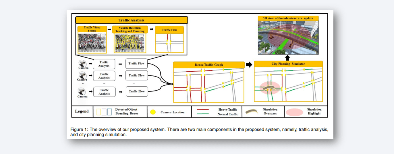
Figure 2 provides an overview of our traffic data analysis approach. Initially, video frames are processed using a YOLO detector for object detection, specifically focused on vehicles. The DeepSORT tracker is then employed to track these vehicles across frames, allowing us to determine their trajectories and velocities. Traffic density and flow are estimated based on the number of vehicles and their speeds. Movement vectors are computed for each vehicle and subsequently clustered using KMeans to identify dominant movement directions. These directions are assigned to vehicles by comparing their vectors. Each camera is treated as a vertex in a graph that represents the city map, with graph vertices connected based on real map data. These links contain weights such as road length and vehicle count, forming a dynamic time-series graph for further simulation analysis.
In this study, we introduced a data-driven urban planning simulator. The term "data-driven" signifies that actual traffic data from real videos, not simulated or dummy data, inform our simulation. The vehicles are introduced into the simulator at time, each assigned specific speed and direction. The virtual city scenes mirror real city landscapes, enabling city officials to readily assess the impact of changes like adding or removing structures such as bridges, altering road directions, and more. Utilizing a graph-based framework, the simulator comprehensively visualizes the effects of updates across the entire city. The user-friendly interface supports the addition of new infrastructure items like roads, overpasses, bridges, tunnels, and traffic lights. Changes in traffic direction, from one-way to two-way and vice versa, are also possible. These alterations are reflected in the graph through edge addition/removal and weight adjustments, subsequently affecting neighboring nodes. After graph updates, traffic estimates are recalculated to suit the revised graph, distributing traffic load as depicted in Figure 3.
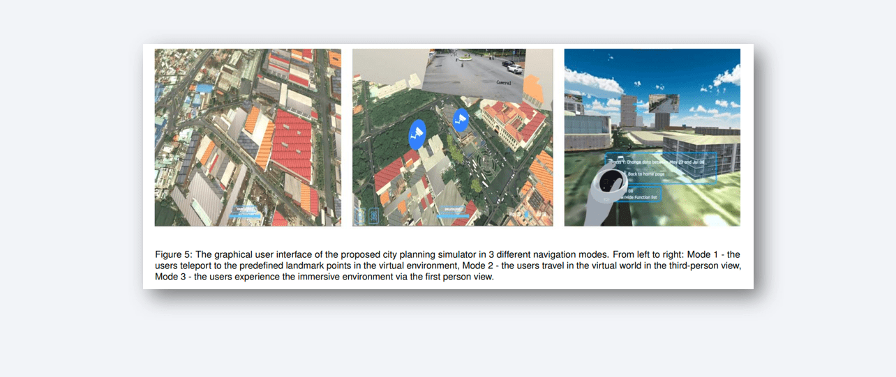
We created a simulator using the Unity3D engine to implement our system prototype in Ho Chi Minh City, chosen for its congested traffic and available public camera grid. In the traffic analysis phase, we gathered 26,821 video frames, manually marked 244,106 bounding boxes for vehicle types, and utilized this dataset for training vehicle detection and tracking models. For 3D modeling, city structures were built in Blender, incorporating real-world height maps and satellite images from Google Maps. These 3D models were then integrated into the Unity3D city simulator. The traffic simulation was informed by analyzed traffic data, spawning 3D vehicles with realistic travel paths and incorporating reference camera videos. Our simulation, deployed on an Oculus Quest VR headset, offers three modes: Mode 1 (teleportation between landmarks), Mode 2 (third-person navigation), and Mode 3 (first-person navigation), addressing the challenges of navigating within a virtual city [6].

Our study was approved by the university's Institutional Review Board (IRB). Following established guidelines , we engaged 25 participants, including 12 females, primarily university students and staff, with ages ranging from 19 to 44 (average age of 26.6). Participants were introduced to three modes for evaluation:
each assessed based on criteria such as ease of use, convenience, realism, functionality, and preference. Ratings were given on a 5-point Likert scale. Results showed that Modes 1 and 2 were rated highly for ease of use, while Modes 2 and 3 excelled in convenience and realism. Modes 2 and 3 were preferred, with participants valuing the ability to interact with virtual elements. Feedback also suggested potential improvements, including enhancing VR headset fidelity, incorporating holographic road names, and adding a minimap feature. Participants envisioned broader applications in various environments, highlighting the system's potential for future utilization.

Sure thing! So, imagine this cool paper we wrote. We came up with this awesome city traffic planning simulator that's all about using real traffic data. We take that data and plug it into our simulator that's like a game. You can mess around with the city stuff, like roads and buildings, and see how it affects the traffic. We checked out different versions of our simulator to see which one people like best in terms of how easy it is to use, how cool it feels, and all that.
Guess what? People really liked the version where you see the city from above, kind of like a video game, because it's easier to handle. And they also loved the full virtual reality version, where you feel like you're actually walking around the city, for a real-feel experience.
Looking ahead, we're planning to make this system even better. We want to try it out in big cities around the world, you know, like New York or Tokyo. And we're thinking about adding more stuff to the simulator, like how much it costs to live in the city, gas prices, birth rates, and how much land costs. So, this is just the beginning, and we're hoping more folks will jump in and explore data-driven simulations as virtual reality becomes even cooler.
This work was partially funded by National Science Foundation (NSF) under Grant 2025234. This research was also funded by Vingroup and supported by Vingroup Innovation Foundation (VINIF) under project code VINIF.2019.DA19.
Tam V Nguyen, Thanh Ngoc-Dat Tran, Viet-Tham Huynh, Bao Truong, Minh-Quan Le, Mohit Kumavat, Vatsa S Patel, Mai-Khiem Tran, Minh-Triet Tran